A country story / DO
Dominican Republic
Build on a country that already grows
From early sugar mills to tobacco around Santiago and mixed banana, cacao and coffee farms, the Dominican Republic’s agricultural history has many centres of skill and production.
Preparation stage · available acreage not established
01How the landscape took shape
Several agricultural stories share one country
The early sugar mills of Hispaniola connected rivers, fields, labour and overseas trade. The Dominican Republic’s heritage submission records sites including Boca de Nigua, where enslaved people rebelled in 1796. These remains hold a history of production and coercion that belongs alongside any account of agricultural wealth.[1]
Other crops developed their own regional institutions and expertise. Santiago’s importance to tobacco growing was recognised when the national tobacco institute moved there in 1962. Its move to the Quinigua experimental station in 1991 reflects a continuing tradition of agricultural research and technical support.[2]
02The country today
A diverse sector with room to improve
Today’s banana production illustrates that diversity. A World Bank study describes household growing, mixed systems where bananas accompany cacao and coffee, and specialised commercial farms supplying domestic and export markets. Different farm sizes and production systems therefore sit behind a crop that might appear as a single category on a map.[3]
Growing a marketable crop does not always secure a household’s food. The World Bank–FAO study found food insecurity among smallholder banana producers and weaknesses in how market information reaches farmers. The 2026 sector review places inclusion, competitiveness and climate resilience among the priorities for agriculture’s next stage.[3][4]
03What CaribVista could contribute
Turn a promising idea into a tested practice
CaribVista proposes working with interested producer groups, agronomists and buyers on a focused demonstration. The crop mix would be chosen after conversations about food demand, water, soils, labour and existing farm commitments. Practical courses would connect those decisions to planting, harvesting, record keeping and selling.
The pilot would compare costs, harvests and household benefits across seasons before recommending expansion. Agroforestry could be tested where growers want it and site conditions support it; existing farms, community interests and natural habitats would remain central to site selection. Regional exchange would then share what the trial actually taught.
04 / Read the landscape
Put the story beside the map.
With that history in mind, explore Dominican Republic in natural colour, through its vegetation signal and by mapped land cover. These views help frame local questions; the land records and field assessment establish what a specific site can offer.
From the satellite record
See the land.
Read the signal.
Explore the same landscape in natural colour and through its vegetation signal.
Sentinel-2 · January–September 2026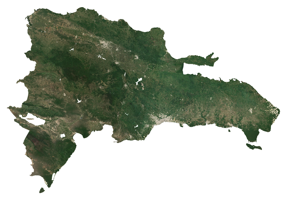
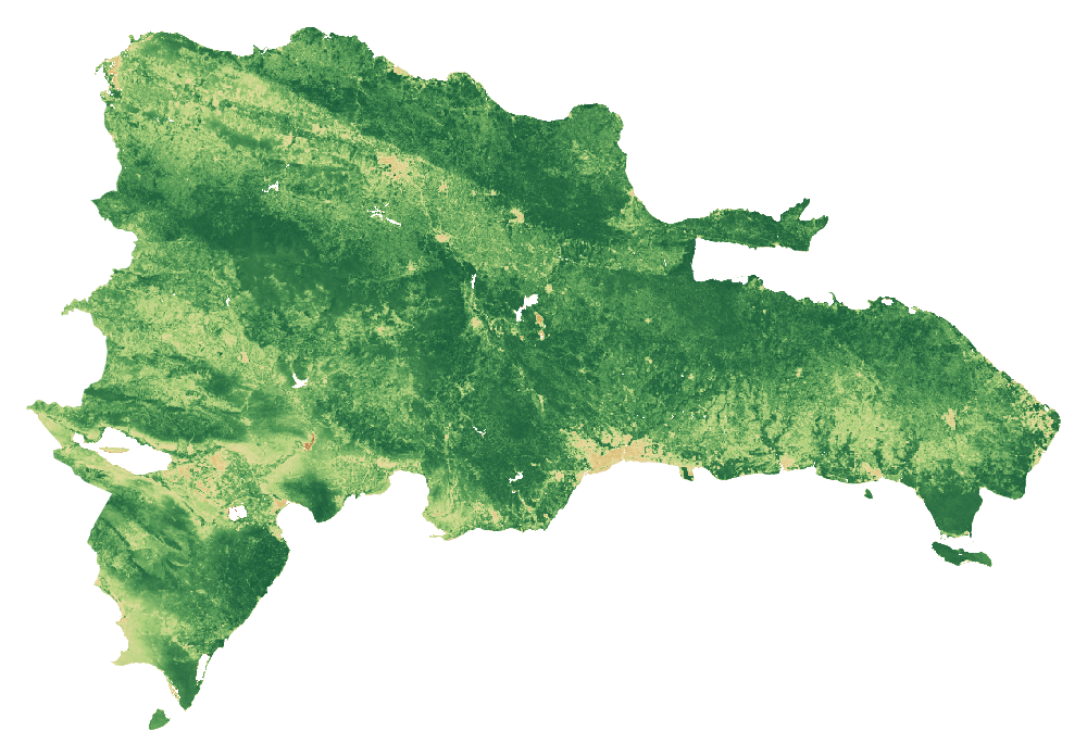 RGB · Natural colourDominican RepublicCloud-screened median composites
Stronger vegetation signals can include forests, pasture and crops. The dark background shows masked water, areas outside the study boundary or missing data.
How to read these images and inspect the sources
Natural colour combines the red, green and blue bands (B4, B3, B2). NDVI compares near-infrared and red reflectance: (B8 − B4) / (B8 + B4). Both views use the same dated scene list and extent, with cloud and shadow screening. Each pixel summarises observations across the period; this is not a single photograph.
The colour scale is fixed across countries; values beyond its endpoints use the endpoint colours. The separate NDVI statistic is the spatial mean of the temporal-median index on the documented 1 km screening grid. Image pixels use the display grid stated above.
These views help guide a closer inspection. They do not identify available rental land, confirm ownership or measure agricultural suitability.
- A temporal median of observations in January–September 2026, not a single-date photograph.
- RGB and NDVI use identical bounds, display grid and valid-pixel masks. Higher NDVI indicates greater spectral greenness, not crop identity, yield, land vacancy or suitability.
- Transparent pixels represent the selected boundary/land mask or missing valid observations, not proof of absent vegetation.
- The overview grid is for display. The published numerical screening uses a separate 1 km grid; do not extract hectares or availability from these coloured pixels.
- Cloud and shadow masking can leave residual haze or remove valid surfaces. Native 10 m source bands do not make the overview a 10 m product.
Download the imagery reproduction package ↓
Contains modified Copernicus Sentinel data (2026), processed for CaribVista.
The 2021 land-cover baseline
What covers the landscape?
Dominican Republic4,809,852.4 mapped hectaresAll classified pixels in the selected boundary, including water
Explore a class in the chart or legend.
Grassland
1,374,363.6 haThis class includes managed pasture and natural grassland. It does not identify vacant, idle, leasable or cultivable land.
View the values and boundary notes
| Land-cover class | Hectares | Share |
|---|---|---|
| Tree cover | 2,732,456.2 | 56.8% |
| Shrubland | 270,630.6 | 5.6% |
| Grassland | 1,374,363.6 | 28.6% |
| Cropland | 210,130.8 | 4.4% |
| Built-up | 100,484.6 | 2.1% |
| Bare / sparse vegetation | 29,809.4 | 0.6% |
| Snow and ice | 0 | 0.0% |
| Permanent water | 52,849 | 1.1% |
| Herbaceous wetland | 17,143.4 | 0.4% |
| Mangroves | 21,984.7 | 0.5% |
| Moss and lichen | 0 | 0.0% |
| Total mapped area | 4,809,852.4 | 100% |
Boundary source: FAO/GAUL/2015/level0. Calculation: 11 October 2026. Rounded values may not add exactly; downloads retain the source values.
- Selected national polygon was matched uniquely; mapped area and reference surface were compared. Coastline and all minor island membership are not certified by a national agency.
- Earth Engine geometry area and raster pixelArea use different area conventions; their ratio is a sanity check, not a valid-pixel or classification-accuracy percentage.
ESA WorldCover 2021 v200 · Historical observations · Reviewed 11 October 2026.
Shares use classified pixel area inside each selected screening boundary, including mapped water. They do not measure available farmland. Local classification accuracy and parcel availability are not established.
05Land and access
From a land lead
to a workable parcel.
A country programme or a patch of grassland helps direct the search. A pilot needs a specific place, clear rights and a current agreement.
IAD’s 2025 reorganization announcement scheduled productive services to Agriculture and wells/pumps to INDRHI from January 2026 while retaining agrarian reform/title functions. A September 2026 notice addresses irregular occupation of reform settlements.
- Presidency: IAD institutional reorganization 2025 announcement; changes scheduled from 2026-01-01
- Presidency: protecting agrarian reform land 2026-09-15
What the satellite evidence supports
A fresh calculation using the documented country boundary is complete. Source artifacts, area checks and processing details are preserved. Local classification accuracy and legal land access have not been established.
Land cover describes vegetation; it does not establish vacant, accessible or plantable land. ESA WorldCover v200 observes 2021. Newer Sentinel screening has its own dates, quality controls and geographic scope.
Boundary scope: Selected national polygon was matched uniquely; mapped area and reference surface were compared. Coastline and all minor island membership are not certified by a national agency. Earth Engine geometry area and raster pixelArea use different area conventions; their ratio is a sanity check, not a valid-pixel or classification-accuracy percentage.
A separate Sentinel-2 screening for January–September 2026 completed on a 1 km sampling grid. It checks the monitoring workflow and records observation coverage. It is too coarse for parcel decisions and does not establish current land use or availability.
ESA dataset and methodologyHistorical programmes and listings need current written confirmation. Gross parcel area and net plantable area are separate decisions.
06Production priorities
Design around the site
and the people using it.
Trace irrigation rights and service responsibility for the exact district, then test quality, delivery reliability, drainage, farm roads, packing/export compliance and buyer payment terms. National output does not establish a site’s cost competitiveness.
Compare proposed production with current use. Protect existing livelihoods and valuable habitats. Choose crops and farming systems after soil, water, market and farm-management checks.
These are proposed feasibility priorities. Sources provide country context and do not establish a CaribVista partnership.
08Check the evidence
Country sources, dates and access limits 11 records · Reviewed 11 October 2026
History and local context
- Dominican Republic submission to UNESCO — First colonial sugar mills of America ↗2018-02-05
- INTABACO — Institutional history ↗
- World Bank and FAO — Market structure and efficiency in agricultural value chains, Dominican banana case study ↗2025
- World Bank — Dominican Republic Agricultural Sector Review ↗2026-06-30
Land, agriculture and programme evidence
Records distinguish primary text reviewed from excerpts and material that could not be retrieved. A source’s publication date and the review date serve different purposes.
- ONE: definitive results of agricultural pre-census 2015
2016-06-09; 2015 reference
Access: primary text reviewed. Producer/unit location and basic characterization. A pre-census is not a full current agricultural census. Accessed on the review date; this does not make historic data current.
- Presidency: 2025 agricultural production
2026-07-13; 2025 reference
Access: primary text reviewed. Official production account. National totals are not yields or margins for a CaribVista pilot. Accessed on the review date; this does not make historic data current.
- Presidency: IAD institutional reorganization
2025 announcement; changes scheduled from 2026-01-01
Access: primary text reviewed. Productive services to Agriculture and wells/pumps to INDRHI; IAD retains agrarian reform and title functions. Confirm operational routing locally. Accessed on the review date; this does not make historic data current.
- Dominican Ministry crop area, harvest and production data
Series includes monthly data through June 2026
Access: primary text reviewed. Official CSV listings; individual quantities not independently recompiled here. Accessed on the review date; this does not make historic data current.
- Presidency: protecting agrarian reform land
2026-09-15
Access: primary text reviewed. Current notice of irregular occupation and title/security issues in settlements; no free-land offer. Accessed on the review date; this does not make historic data current.
- ESA WorldCover data access
2021 reference map; 2022 release
Access: primary text reviewed. WorldCover v 200 is land cover, not a cadastral, vacancy, crop-yield or legal-availability survey. Accessed on the review date; this does not make historic data current.
- IAD–UNMUNDO rural-women agreement
2026-09; exact day not given
Access: Full official article read and text archived.. UNMUNDO may refer rural women for consideration for productive land access, subject to legal criteria and land availability. No named parcel inventory or automatic eligibility for CaribVista or its founder.
The next conversation
Help shape a pilot in Dominican Republic.
Bring a local delivery team, a candidate site or a route to customers and households. Together, the next task is to agree the preparation work, its responsibilities and its budget.
Discuss a preparation partnershipAn invitation to prepare a project. Sites, funding and operating partnerships are still to be agreed.