A country story / LC
Saint Lucia
Family farms and the changing journey of the banana
Saint Lucia's banana trade connected family farms to European markets and supported rural incomes. As markets changed, growers faced the challenge of sustaining that livelihood while finding new crops and customers.
Preparation stage · available acreage not established
01A crop woven into rural life
Small farms in a global trade
Saint Lucia's banana history belongs to the wider Windward Islands story of small farms and family labour. Preferential access to European markets helped support the trade. For rural households, bananas brought regular income and connected the work of growing, harvesting and packing to customers far from home.[1]
FAO's 2003 account records falling banana prices and declining export earnings during the 1990s, including in Saint Lucia. It describes an industry under pressure that still mattered deeply to rural life. The change was a livelihood question for farming families as well as a trade question for government.[1]
02Growers adapting
Different markets, continuing commitments
The government's 2024–2025 Budget Address describes a shift towards regional banana markets and efforts to diversify agricultural production, including cocoa propagation. It also identifies marketing and packaging difficulties. Growing the crop remains only one part of getting a useful, saleable harvest to customers.[2]
In July 2025, the government announced an insurance initiative for registered banana and plantain farmers against wind damage from storms and hurricanes. The initiative is intended to help growers recover from weather shocks and continue farming.[3]
03A possible next chapter
Support the farm and its route to customers
CaribVista proposes working with interested Saint Lucian growers on a pilot that combines practical training with dependable sales. Crop choices could include food crops and appropriate tree crops, guided by farmers' experience and local advice on soils, water and slope. Protecting soil and existing habitats would be part of that design.
Participants would test harvest planning, handling and transport alongside cultivation. The goal would be a farm system that can earn a living while delivering food people can access and afford. Records of deliveries, costs and losses would let growers decide which practices deserve to continue or expand.
04 / Read the landscape
Put the story beside the map.
With that history in mind, explore Saint Lucia in natural colour, through its vegetation signal and by mapped land cover. These views help frame local questions; the land records and field assessment establish what a specific site can offer.
From the satellite record
See the land.
Read the signal.
Explore the same landscape in natural colour and through its vegetation signal.
Sentinel-2 · January–September 2026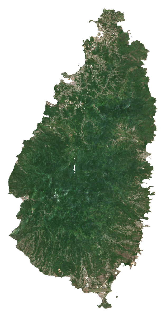
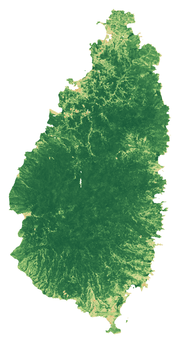 RGB · Natural colourSaint LuciaCloud-screened median composites
Stronger vegetation signals can include forests, pasture and crops. The dark background shows masked water, areas outside the study boundary or missing data.
How to read these images and inspect the sources
Natural colour combines the red, green and blue bands (B4, B3, B2). NDVI compares near-infrared and red reflectance: (B8 − B4) / (B8 + B4). Both views use the same dated scene list and extent, with cloud and shadow screening. Each pixel summarises observations across the period; this is not a single photograph.
The colour scale is fixed across countries; values beyond its endpoints use the endpoint colours. The separate NDVI statistic is the spatial mean of the temporal-median index on the documented 1 km screening grid. Image pixels use the display grid stated above.
These views help guide a closer inspection. They do not identify available rental land, confirm ownership or measure agricultural suitability.
- A temporal median of observations in January–September 2026, not a single-date photograph.
- RGB and NDVI use identical bounds, display grid and valid-pixel masks. Higher NDVI indicates greater spectral greenness, not crop identity, yield, land vacancy or suitability.
- Transparent pixels represent the selected boundary/land mask or missing valid observations, not proof of absent vegetation.
- The overview grid is for display. The published numerical screening uses a separate 1 km grid; do not extract hectares or availability from these coloured pixels.
- Cloud and shadow masking can leave residual haze or remove valid surfaces. Native 10 m source bands do not make the overview a 10 m product.
Download the imagery reproduction package ↓
Contains modified Copernicus Sentinel data (2026), processed for CaribVista.
The 2021 land-cover baseline
What covers the landscape?
Saint Lucia60,279.8 mapped hectaresAll classified pixels in the selected boundary, including water
Explore a class in the chart or legend.
Grassland
3,091.7 haThis class includes managed pasture and natural grassland. It does not identify vacant, idle, leasable or cultivable land.
View the values and boundary notes
| Land-cover class | Hectares | Share |
|---|---|---|
| Tree cover | 53,840.9 | 89.3% |
| Shrubland | 44.4 | <0.1% |
| Grassland | 3,091.7 | 5.1% |
| Cropland | 27.2 | <0.1% |
| Built-up | 2,625.5 | 4.4% |
| Bare / sparse vegetation | 116.8 | 0.2% |
| Snow and ice | 0 | 0.0% |
| Permanent water | 302.6 | 0.5% |
| Herbaceous wetland | 91 | 0.2% |
| Mangroves | 139.7 | 0.2% |
| Moss and lichen | 0 | 0.0% |
| Total mapped area | 60,279.8 | 100% |
Boundary source: FAO/GAUL/2015/level0. Calculation: 11 October 2026. Rounded values may not add exactly; downloads retain the source values.
- Selected national polygon was matched uniquely; mapped area and reference surface were compared. Coastline and all minor island membership are not certified by a national agency.
- Earth Engine geometry area and raster pixelArea use different area conventions; their ratio is a sanity check, not a valid-pixel or classification-accuracy percentage.
ESA WorldCover 2021 v200 · Historical observations · Reviewed 11 October 2026.
Shares use classified pixel area inside each selected screening boundary, including mapped water. They do not measure available farmland. Local classification accuracy and parcel availability are not established.
05Land and access
From a land lead
to a workable parcel.
A country programme or a patch of grassland helps direct the search. A pilot needs a specific place, clear rights and a current agreement.
The National Landbank process calls for proof of ownership/authority, suitability/vacancy checks and registered agreements; all owners must participate where applicable. The page’s programme narrative refers to 2019/2020, so current intake must be confirmed.
Concession guidance requires tenure documentation and a recent land register where relevant.
- Saint Lucia agricultural concessions application process Page hosts 2022 application material
What the satellite evidence supports
A fresh calculation using the documented country boundary is complete. Source artifacts, area checks and processing details are preserved. Local classification accuracy and legal land access have not been established.
Land cover describes vegetation; it does not establish vacant, accessible or plantable land. ESA WorldCover v200 observes 2021. Newer Sentinel screening has its own dates, quality controls and geographic scope.
Boundary scope: Selected national polygon was matched uniquely; mapped area and reference surface were compared. Coastline and all minor island membership are not certified by a national agency. Earth Engine geometry area and raster pixelArea use different area conventions; their ratio is a sanity check, not a valid-pixel or classification-accuracy percentage.
A separate Sentinel-2 screening for January–September 2026 completed on a 1 km sampling grid. It checks the monitoring workflow and records observation coverage. It is too coarse for parcel decisions and does not establish current land use or availability.
ESA dataset and methodologyHistorical programmes and listings need current written confirmation. Gross parcel area and net plantable area are separate decisions.
06Production priorities
Design around the site
and the people using it.
The 2025 review discusses agricultural operating costs, labour and logistics alongside crop performance. Measure dry-season supply, rainfall/runoff and slope access. Obtain current packhouse, transport, buyer and storage capacity rather than inferring it from distance to a road.
Compare proposed production with current use. Protect existing livelihoods and valuable habitats. Choose crops and farming systems after soil, water, market and farm-management checks.
- Saint Lucia Economic and Social Review 2025 2025 reference; publication date unconfirmed
These are proposed feasibility priorities. Sources provide country context and do not establish a CaribVista partnership.
08Check the evidence
Country sources, dates and access limits 8 records · Reviewed 11 October 2026
History and local context
Land, agriculture and programme evidence
Records distinguish primary text reviewed from excerpts and material that could not be retrieved. A source’s publication date and the review date serve different purposes.
- ESA WorldCover data access
2021 reference map; 2022 release
Access: primary text reviewed. WorldCover v 200 is land cover, not a cadastral, vacancy, crop-yield or legal-availability survey. Accessed on the review date; this does not make historic data current.
- Saint Lucia agriculture and fisheries census page
Publication date not established
Access: primary text reviewed. Announces 2025 census and prior 2007 census; internal pilot/training date inconsistencies. No new final tables verified. Accessed on the review date; this does not make historic data current.
- Saint Lucia agricultural concessions application process
Page hosts 2022 application material
Access: primary text reviewed. Tenure documents and land register needed; crop categories and capability criteria, not project eligibility guaranteed. Accessed on the review date; this does not make historic data current.
- Saint Lucia National Landbank
Publication date not established
Access: primary text reviewed. Describes title, owner consent, parcel suitability/vacancy checks and leases; narrative references 2019/2020 rollout, not fresh availability. Accessed on the review date; this does not make historic data current.
- Saint Lucia Economic and Social Review 2025
2025 reference; publication date unconfirmed
Access: primary text reviewed. Agricultural subsectors and supermarket/hotel purchasing; figures marked preliminary. Purchases are not total national crop output. Accessed on the review date; this does not make historic data current.
The next conversation
Help shape a pilot in Saint Lucia.
Bring a local delivery team, a candidate site or a route to customers and households. Together, the next task is to agree the preparation work, its responsibilities and its budget.
Discuss a preparation partnershipAn invitation to prepare a project. Sites, funding and operating partnerships are still to be agreed.