A country story / BB
Barbados
From a sugar landscape to a broader food future
Sugar reshaped Barbados's land, labour and trade. Alongside that plantation history runs another story: people growing provisions, keeping livestock and building livelihoods from the land.
Preparation stage · available acreage not established
01The landscape we inherited
Fields connected to a wider world
From the 1640s, sugar transformed Barbados. Estates consolidated land, mills processed cane, and roads carried produce towards Bridgetown and overseas markets. Enslaved Africans supplied the forced labour on which this system depended. The island's sugar heritage records a profound transformation of society as well as an agricultural industry.[1]
Within that unequal system, enslaved people and their descendants also grew provisions and traded surpluses. Their work, resistance and everyday enterprise belong in the agricultural story alongside the estates and factories.[1]
02Farming continues
A living sector, with practical needs
Today's farming landscape already includes vegetables, orchards, livestock, aquaculture and beekeeping. BADMC describes services ranging from extension advice and tractor work to irrigation and agricultural leases. Any new initiative would enter a country with growers, skills and institutions already at work.[2]
Water remains a concrete part of the development agenda. A 2024 FAO investment proposal for Spring Hall and Chance Hall centres on storing rainfall and supporting irrigation through the dry season. Its focus is on keeping farms supplied when rainfall is least dependable.[3]
03A possible next chapter
Make local growing dependable
CaribVista proposes developing a first pilot with willing Barbadian growers, landholders and local trainees. Together they would choose crops around dependable water, suitable soils and a clear route to households and buyers. Existing grazing, ecological value and heritage would shape which places and methods make sense.
The aim would be to connect supervised learning with everyday farm work: planting, maintaining irrigation, harvesting and recording costs. A successful pilot would need to demonstrate reliable food deliveries, a fair livelihood for growers and prices that people can afford before expansion is considered.
04 / Read the landscape
Put the story beside the map.
With that history in mind, explore Barbados in natural colour, through its vegetation signal and by mapped land cover. These views help frame local questions; the land records and field assessment establish what a specific site can offer.
From the satellite record
See the land.
Read the signal.
Explore the same landscape in natural colour and through its vegetation signal.
Sentinel-2 · January–September 2026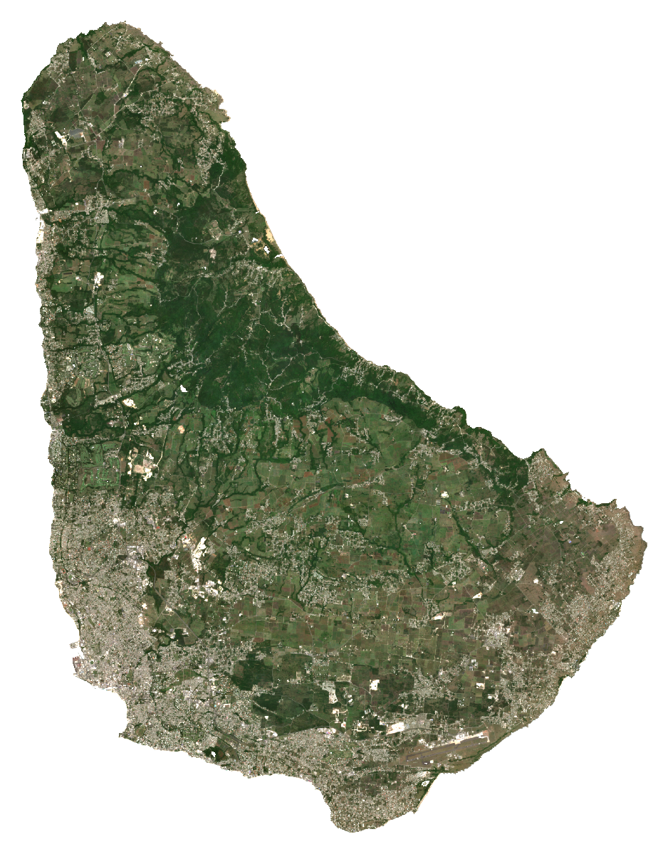
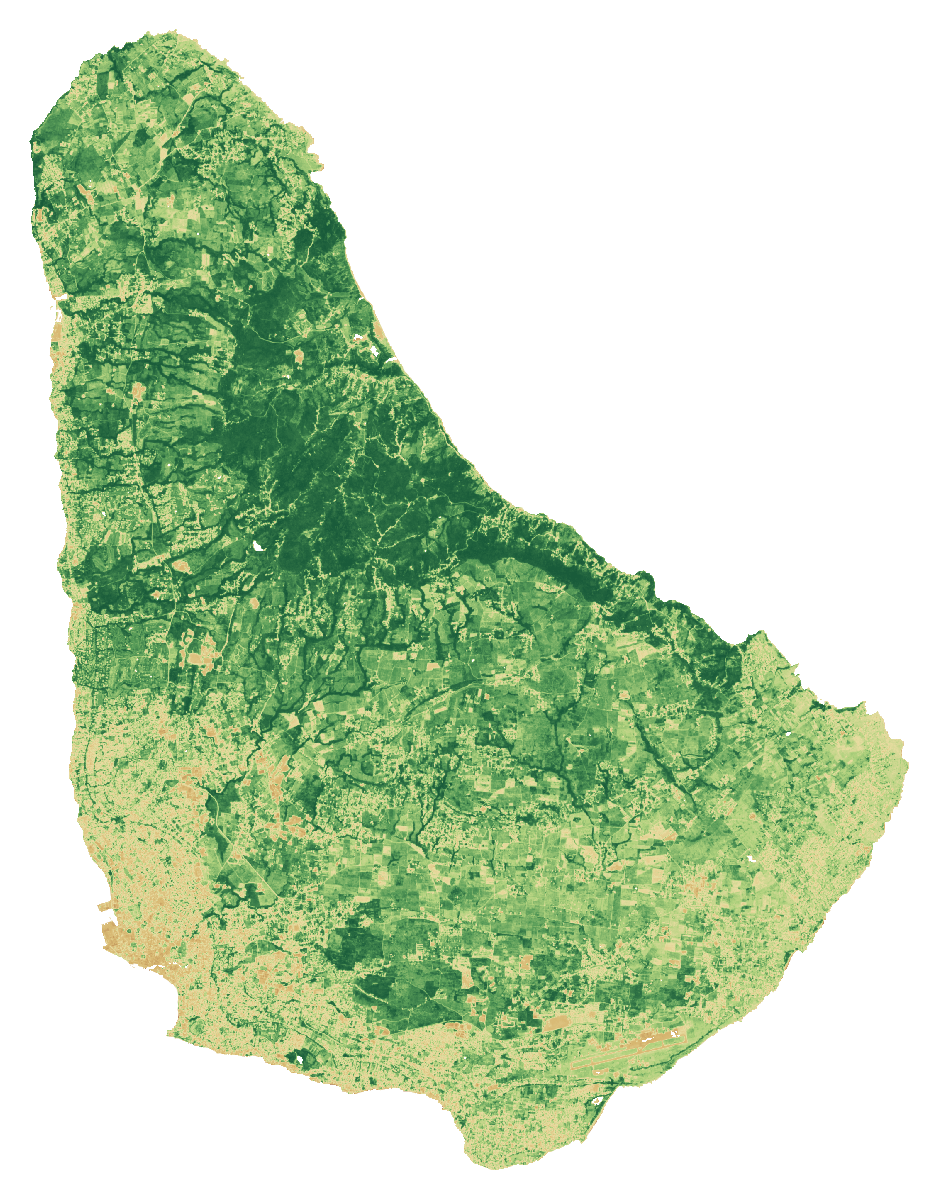 RGB · Natural colourBarbadosCloud-screened median composites
Stronger vegetation signals can include forests, pasture and crops. The dark background shows masked water, areas outside the study boundary or missing data.
A monitoring example · Barbados
Greenness changes through the months.
Each point is the spatial mean of that month’s median NDVI over observed grid cells. Different months can have different clear views.
NDVI axis: 0 to 1. Seasonal conditions, cloud screening and changes in observed cells can influence this line. It is not a measure of harvests, crop health or available land.
Monthly values and observation coverage
| 2026 month | Mean NDVI | Observed cells | Grid-cell coverage | Source granules |
|---|---|---|---|---|
| Jan | 0.621 | 412 / 416 | 99.0% | 10 |
| Feb | 0.590 | 413 / 416 | 99.3% | 11 |
| Mar | 0.539 | 410 / 416 | 98.6% | 9 |
| Apr | 0.462 | 397 / 416 | 95.4% | 7 |
| May | 0.412 | 415 / 416 | 99.8% | 14 |
| Jun | 0.344 | 342 / 416 | 82.2% | 11 |
| Jul | 0.537 | 408 / 416 | 98.1% | 13 |
| Aug | 0.529 | 416 / 416 | 100.0% | 12 |
| Sept | 0.597 | 416 / 416 | 100.0% | 12 |
Coverage refers to cells on this fixed grid, not national area coverage or classification accuracy. Monthly medians cannot be averaged to reproduce the full-period median. The monthly grid is pinned separately from the archived screening calculation.
Download the monthly values and method ↓How to read these images and inspect the sources
Natural colour combines the red, green and blue bands (B4, B3, B2). NDVI compares near-infrared and red reflectance: (B8 − B4) / (B8 + B4). Both views use the same dated scene list and extent, with cloud and shadow screening. Each pixel summarises observations across the period; this is not a single photograph.
The colour scale is fixed across countries; values beyond its endpoints use the endpoint colours. The separate NDVI statistic is the spatial mean of the temporal-median index on the documented 1 km screening grid. Image pixels use the display grid stated above.
These views help guide a closer inspection. They do not identify available rental land, confirm ownership or measure agricultural suitability.
- A temporal median of observations in January–September 2026, not a single-date photograph.
- RGB and NDVI use identical bounds, display grid and valid-pixel masks. Higher NDVI indicates greater spectral greenness, not crop identity, yield, land vacancy or suitability.
- Transparent pixels represent the selected boundary/land mask or missing valid observations, not proof of absent vegetation.
- The overview grid is for display. The published numerical screening uses a separate 1 km grid; do not extract hectares or availability from these coloured pixels.
- Cloud and shadow masking can leave residual haze or remove valid surfaces. Native 10 m source bands do not make the overview a 10 m product.
Download the imagery reproduction package ↓
Contains modified Copernicus Sentinel data (2026), processed for CaribVista.
The 2021 land-cover baseline
What covers the landscape?
Barbados43,302 mapped hectaresAll classified pixels in the selected boundary, including water
Explore a class in the chart or legend.
Grassland
13,475.9 haThis class includes managed pasture and natural grassland. It does not identify vacant, idle, leasable or cultivable land.
View the values and boundary notes
| Land-cover class | Hectares | Share |
|---|---|---|
| Tree cover | 17,162.1 | 39.6% |
| Shrubland | 36.2 | <0.1% |
| Grassland | 13,475.9 | 31.1% |
| Cropland | 3,567.4 | 8.2% |
| Built-up | 8,694.9 | 20.1% |
| Bare / sparse vegetation | 168 | 0.4% |
| Snow and ice | 0 | 0.0% |
| Permanent water | 168 | 0.4% |
| Herbaceous wetland | 17.4 | <0.1% |
| Mangroves | 12.1 | <0.1% |
| Moss and lichen | 0 | 0.0% |
| Total mapped area | 43,302 | 100% |
Boundary source: FAO/GAUL/2015/level0. Calculation: 11 October 2026. Rounded values may not add exactly; downloads retain the source values.
- Selected national polygon was matched uniquely; mapped area and reference surface were compared. Coastline and all minor island membership are not certified by a national agency.
- Earth Engine geometry area and raster pixelArea use different area conventions; their ratio is a sanity check, not a valid-pixel or classification-accuracy percentage.
ESA WorldCover 2021 v200 · Historical observations · Reviewed 11 October 2026.
Shares use classified pixel area inside each selected screening boundary, including mapped water. They do not measure available farmland. Local classification accuracy and parcel availability are not established.
05Land and access
From a land lead
to a workable parcel.
A country programme or a patch of grassland helps direct the search. A pilot needs a specific place, clear rights and a current agreement.
BADMC describes an existing subsidised lease/licence programme serving 215 farmers on over 1,300 acres; these are occupied programme totals. It mentions 12-month renewable licences.
Tree investments require an enforceable tenure term compatible with establishment and harvest, renewal/termination terms, and compensation arrangements. The unnamed trust recalled by the founder remains unidentified.
Codrington is only a possible identification lead, not a confirmed match. USPG describes an active reparative/community programme and resident tenants on the estate. No vacant agricultural parcel or lease offer was identified there.
- USPG: The Codrington Project Announced 2023-09-08; page includes 2024 updates
- USPG annual review 2024: Codrington community programme 2024 report; hosted 2025
What the satellite evidence supports
A fresh calculation using the documented country boundary is complete. Source artifacts, area checks and processing details are preserved. Local classification accuracy and legal land access have not been established.
Land cover describes vegetation; it does not establish vacant, accessible or plantable land. ESA WorldCover v200 observes 2021. Newer Sentinel screening has its own dates, quality controls and geographic scope.
Boundary scope: Selected national polygon was matched uniquely; mapped area and reference surface were compared. Coastline and all minor island membership are not certified by a national agency. Earth Engine geometry area and raster pixelArea use different area conventions; their ratio is a sanity check, not a valid-pixel or classification-accuracy percentage.
A separate Sentinel-2 screening for January–September 2026 completed on a 1 km sampling grid. It checks the monitoring workflow and records observation coverage. It is too coarse for parcel decisions and does not establish current land use or availability.
ESA dataset and methodologyHistorical programmes and listings need current written confirmation. Gross parcel area and net plantable area are separate decisions.
06Production priorities
Design around the site
and the people using it.
FAO’s 2024 Hand-in-Hand proposal includes Spring Hall/Chance Hall irrigation. It is an investment proposal, not evidence of a vacant plot or completed works. Obtain a dry-season water allocation, pumping/storage design and delivered-water cost; sample irrigation water and confirm road, packhouse and buyer access before sizing the pilot.
Compare proposed production with current use. Protect existing livelihoods and valuable habitats. Choose crops and farming systems after soil, water, market and farm-management checks.
These are proposed feasibility priorities. Sources provide country context and do not establish a CaribVista partnership.
08Check the evidence
Country sources, dates and access limits 15 records · Reviewed 11 October 2026
History and local context
- Barbados National Commission for UNESCO: The Industrial Heritage of Barbados — The Story of Sugar and Rum (Tentative List submission) ↗2014-12-02
- Barbados Agricultural Development and Marketing Corporation: Agricultural services ↗
- FAO Hand-in-Hand Investment Forum 2024: Caribbean SIDS investment proposals ↗2024
Land, agriculture and programme evidence
Records distinguish primary text reviewed from excerpts and material that could not be retrieved. A source’s publication date and the review date serve different purposes.
- BADMC agricultural services
Publication date not established
Access: primary text reviewed. Existing land, extension and irrigation services; 215 farmers and over 1,300 acres described as already benefiting, not vacant. Accessed on the review date; this does not make historic data current.
- Barbados Ministry: agricultural census
Publication date not established
Access: primary text reviewed. Explains census scope and historical 1989 baseline; no completed new census tables verified. Accessed on the review date; this does not make historic data current.
- USPG: The Codrington Project
Announced 2023-09-08; page includes 2024 updates
Access: primary text reviewed. Primary project description: long-term reparative, community and heritage work. Not established as the trust recalled by the founder, and not a vacant-land listing. Accessed on the review date; this does not make historic data current.
- USPG annual review 2024: Codrington community programme
2024 report; hosted 2025
Access: primary document retrieved relevant text reviewed. Project reporting describes estate tenants and community engagement; source supports occupancy/rights caution, not current parcel boundaries or lease availability. Accessed on the review date; this does not make historic data current.
- Barbados agricultural statistics
Publication date not established
Access: primary text reviewed. Official commodity monitoring portal; individual time series and denominators still need export and reconciliation. Accessed on the review date; this does not make historic data current.
- Belgrave et al.: KX4-Hawaii biomass production in Barbados
2024-09-26
Access: primary research abstract reviewed full text unavailable. Original Barbados hedgerow trial abstract; not a validated whole-farm food-yield or commercial return study. Accessed on the review date; this does not make historic data current.
- FAO Hand-in-Hand 2024: Caribbean SIDS investment proposals
2024
Access: primary text reviewed. Spring Hall/Chance Hall irrigation proposal; proposal cost and footprint do not establish construction, vacant land or investor access. Accessed on the review date; this does not make historic data current.
- CARDI strategic plan 2024–2028
2024–2028 plan
Access: primary text reviewed. Regional research mandate and existing crop, livestock and resilience work; candidate institution, no CaribVista partnership. Accessed on the review date; this does not make historic data current.
- ESA WorldCover data access
2021 reference map; 2022 release
Access: primary text reviewed. WorldCover v 200 is land cover, not a cadastral, vacancy, crop-yield or legal-availability survey. Accessed on the review date; this does not make historic data current.
- FAO agricultural census participation by round
Publication date not established
Access: primary text reviewed. Round listing; a listed year is not proof that final results have been released. Accessed on the review date; this does not make historic data current.
- Codrington Trust Act, Cap. 244
Commencement 1983-10-01; PDF L.R.O. 1985
Access: Official PDF downloaded and relevant provisions read.. Sections 3–5 establish the trust, vest estate interests and preserve obligations. A statute is not a current title search, lease offer or confirmation that this is the founder’s recalled property.
- USPG reparatory justice update
2026-07-23
Access: Primary organisation article reviewed in search-index text.. Reaffirms the Codrington Renewal and Reconciliation Project launched in September 2024. Evidence of existing activity, not an invitation to lease vacant land.
The next conversation
Help shape a pilot in Barbados.
Bring a local delivery team, a candidate site or a route to customers and households. Together, the next task is to agree the preparation work, its responsibilities and its budget.
Discuss a preparation partnershipAn invitation to prepare a project. Sites, funding and operating partnerships are still to be agreed.