A country story / BS
The Bahamas
A food journey across islands
Eleuthera’s pineapple tradition is part of a farming landscape spread across islands. From mixed farms to packing houses, the Bahamian food story follows a harvest’s journey from the field to the people who will use it.
Preparation stage · available acreage not established
01An agricultural heritage that continues
The farmers behind the pineapple
Eleuthera’s pineapple tradition is a reminder that Bahamian food production has its own deep roots. In its June 2026 Pineapple Festival announcement, the Ministry of Tourism honours generations of growers and the sugarloaf pineapple’s place in the island’s identity. The festival began in 1988, celebrating a much older relationship between communities and cultivation.[1]
An earlier Department of Agriculture account, published by FAO in 1992, describes mixed farms, fruit processing and Family Island packing houses. It also records seasonal gluts and shortages. Producing food and getting it to customers have long been connected challenges in the archipelago.[2]
02Different islands, practical expertise
Build on the knowledge already here
FAO’s country overview describes an agricultural geography spread across islands, with differing land and water conditions. It identifies farming on Andros, Abaco, Grand Bahama and other Family Islands, as well as protected vegetable production on New Providence. A national map therefore contains many different growing situations.[3]
Agricultural learning also has an established home. The Bahamas Agriculture and Marine Science Institute offers practical training on its research and demonstration farm, with teaching that includes crop production and natural-resource management. Its students, instructors and working farmers represent experience that a new proposal should respect and seek to complement.[4]
03Where CaribVista could help
Test one complete food route
CaribVista proposes to work with local growers and advisers on one island and a clearly identified market. Together they would test a manageable crop plan, the cost of water and energy, and the full journey through packing, cooling and transport. Household affordability would be considered alongside what the grower earns.
The proposed demonstration would use only an agreed site, with existing rights, freshwater protection and habitats considered before any planting. Satellite observations could help document change; farm records would show whether food arrived in usable condition and at a workable cost. That complete journey would be the basis for considering expansion.
04 / Read the landscape
Put the story beside the map.
With that history in mind, explore The Bahamas in natural colour, through its vegetation signal and by mapped land cover. These views help frame local questions; the land records and field assessment establish what a specific site can offer.
From the satellite record
See the land.
Read the signal.
Explore the same landscape in natural colour and through its vegetation signal.
Sentinel-2 · January–September 2026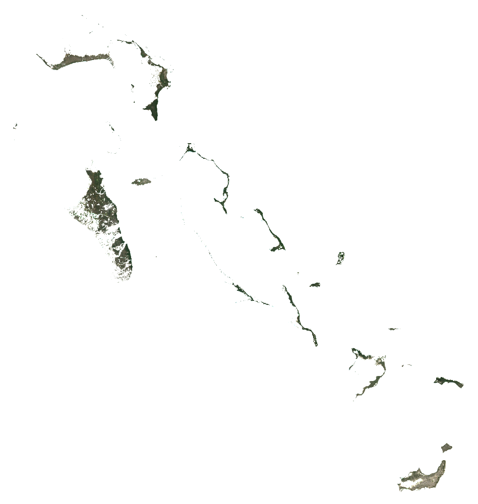
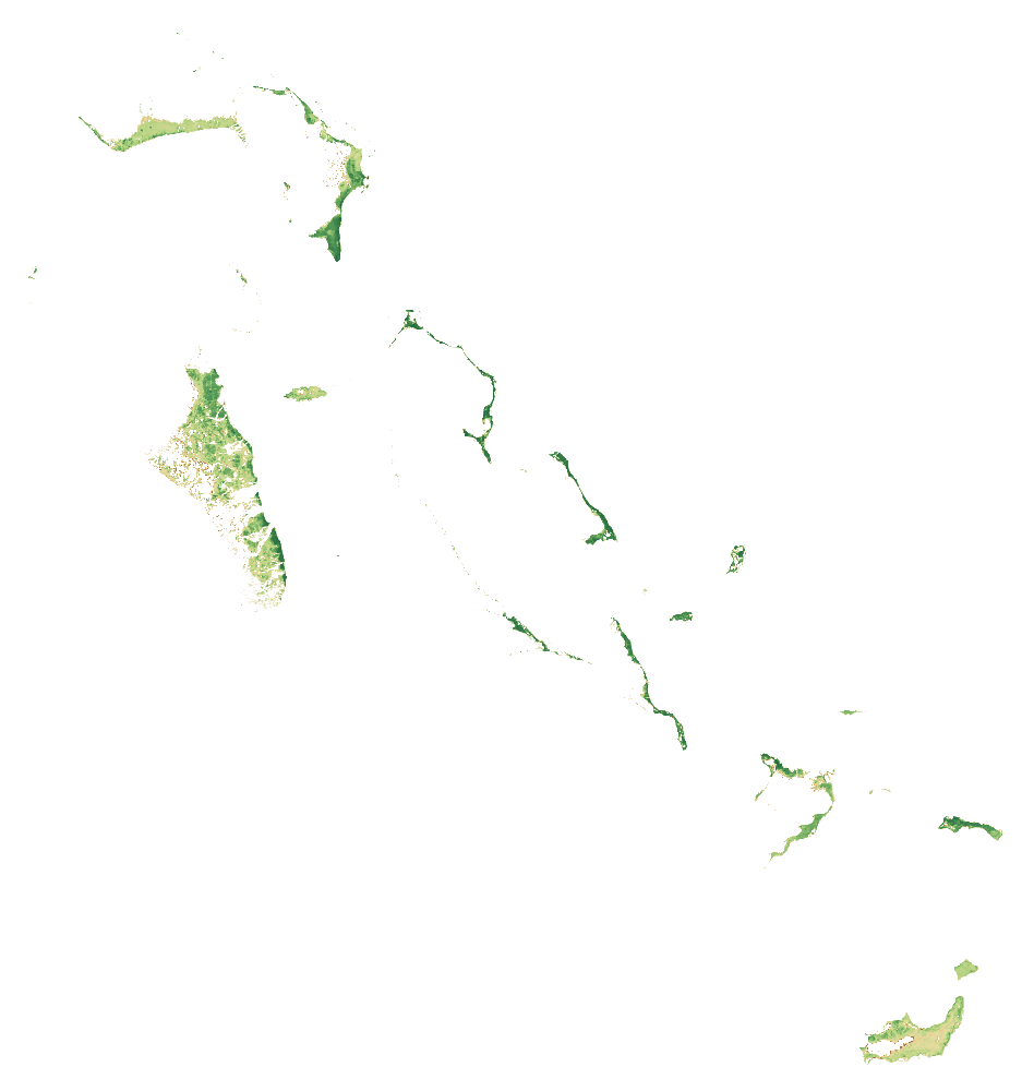 RGB · Natural colourThe BahamasCloud-screened median composites
Stronger vegetation signals can include forests, pasture and crops. The dark background shows masked water, areas outside the study boundary or missing data.
How to read these images and inspect the sources
Natural colour combines the red, green and blue bands (B4, B3, B2). NDVI compares near-infrared and red reflectance: (B8 − B4) / (B8 + B4). Both views use the same dated scene list and extent, with cloud and shadow screening. Each pixel summarises observations across the period; this is not a single photograph.
The colour scale is fixed across countries; values beyond its endpoints use the endpoint colours. The separate NDVI statistic is the spatial mean of the temporal-median index on the documented 1 km screening grid. Image pixels use the display grid stated above.
These views help guide a closer inspection. They do not identify available rental land, confirm ownership or measure agricultural suitability.
- A temporal median of observations in January–September 2026, not a single-date photograph.
- RGB and NDVI use identical bounds, display grid and valid-pixel masks. Higher NDVI indicates greater spectral greenness, not crop identity, yield, land vacancy or suitability.
- Transparent pixels represent the selected boundary/land mask or missing valid observations, not proof of absent vegetation.
- The overview grid is for display. The published numerical screening uses a separate 1 km grid; do not extract hectares or availability from these coloured pixels.
- Cloud and shadow masking can leave residual haze or remove valid surfaces. Native 10 m source bands do not make the overview a 10 m product.
- A full-domain overview of a dispersed archipelago: small islands and narrow features may be only a few display pixels. The source list was selected against the country bounding rectangle; the displayed pixels remain clipped to the national polygon.
Download the imagery reproduction package ↓
Contains modified Copernicus Sentinel data (2026), processed for CaribVista.
The 2021 land-cover baseline
What covers the landscape?
The Bahamas1,190,353.1 mapped hectaresAll classified pixels in the selected boundary, including water
Explore a class in the chart or legend.
Grassland
353,165 haThis class includes managed pasture and natural grassland. It does not identify vacant, idle, leasable or cultivable land.
View the values and boundary notes
| Land-cover class | Hectares | Share |
|---|---|---|
| Tree cover | 368,079.8 | 30.9% |
| Shrubland | 17,813.2 | 1.5% |
| Grassland | 353,165 | 29.7% |
| Cropland | 257.4 | <0.1% |
| Built-up | 12,414.8 | 1.0% |
| Bare / sparse vegetation | 16,212.6 | 1.4% |
| Snow and ice | 0 | 0.0% |
| Permanent water | 179,321.5 | 15.1% |
| Herbaceous wetland | 131,738.4 | 11.1% |
| Mangroves | 111,350.4 | 9.4% |
| Moss and lichen | 0 | 0.0% |
| Total mapped area | 1,190,353.1 | 100% |
Boundary source: FAO/GAUL/2015/level0. Calculation: 11 October 2026. Rounded values may not add exactly; downloads retain the source values.
- Selected national polygon was matched uniquely; mapped area and reference surface were compared. Coastline and all minor island membership are not certified by a national agency.
- Earth Engine geometry area and raster pixelArea use different area conventions; their ratio is a sanity check, not a valid-pixel or classification-accuracy percentage.
ESA WorldCover 2021 v200 · Historical observations · Reviewed 11 October 2026.
Shares use classified pixel area inside each selected screening boundary, including mapped water. They do not measure available farmland. Local classification accuracy and parcel availability are not established.
05Land and access
From a land lead
to a workable parcel.
A country programme or a patch of grassland helps direct the search. A pilot needs a specific place, clear rights and a current agreement.
BAIC publishes a lease application requiring proposed location and business/technical information. The reviewed form was revised in 2019; it establishes neither current vacant land nor current rental terms.
- BAIC lease application Form revision 2019-11-19
What the satellite evidence supports
A fresh calculation using the documented country boundary is complete. Source artifacts, area checks and processing details are preserved. Local classification accuracy and legal land access have not been established.
Land cover describes vegetation; it does not establish vacant, accessible or plantable land. ESA WorldCover v200 observes 2021. Newer Sentinel screening has its own dates, quality controls and geographic scope.
Boundary scope: Selected national polygon was matched uniquely; mapped area and reference surface were compared. Coastline and all minor island membership are not certified by a national agency. Earth Engine geometry area and raster pixelArea use different area conventions; their ratio is a sanity check, not a valid-pixel or classification-accuracy percentage.
A separate Sentinel-2 screening for January–September 2026 completed on a 1 km sampling grid. It checks the monitoring workflow and records observation coverage. It is too coarse for parcel decisions and does not establish current land use or availability.
ESA dataset and methodologyHistorical programmes and listings need current written confirmation. Gross parcel area and net plantable area are separate decisions.
06Production priorities
Design around the site
and the people using it.
BAMSI reported a preliminary solar-irrigation pilot in North Andros in May 2025. Lower costs and improved efficiency were aims, not measured results. Price freshwater abstraction/storage and salinity risk, storm protection, power backup, inter-island freight, refrigeration and buyer delivery. Verify water rights and permits locally.
Compare proposed production with current use. Protect existing livelihoods and valuable habitats. Choose crops and farming systems after soil, water, market and farm-management checks.
- BAMSI solar irrigation pilot in North Andros 2025-05-22
These are proposed feasibility priorities. Sources provide country context and do not establish a CaribVista partnership.
08Check the evidence
Country sources, dates and access limits 10 records · Reviewed 11 October 2026
History and local context
Land, agriculture and programme evidence
Records distinguish primary text reviewed from excerpts and material that could not be retrieved. A source’s publication date and the review date serve different purposes.
- BAMSI School of Agriculture and Natural Resources
Publication date not established
Access: primary text reviewed. Existing practical crop, livestock, agroforestry, soil and protected-farming education; no CaribVista affiliation. Accessed on the review date; this does not make historic data current.
- IICA Bahamas Agricultural Census Pilot Project
Project 2025-02-01 to 2026-02-04
Access: primary text reviewed. Eleuthera and Abaco pilot before potential national rollout; historic national census 1994, no new national results verified. Accessed on the review date; this does not make historic data current.
- BAIC lease application
Form revision 2019-11-19
Access: primary text reviewed. Application form requires proposed location and business/technical information; not current rent or available inventory. Accessed on the review date; this does not make historic data current.
- BAMSI solar irrigation pilot in North Andros
2025-05-22
Access: primary text reviewed. Early pilot/preliminary engagement. Cost reduction is an intended outcome, not measured savings. Accessed on the review date; this does not make historic data current.
- ESA WorldCover data access
2021 reference map; 2022 release
Access: primary text reviewed. WorldCover v 200 is land cover, not a cadastral, vacancy, crop-yield or legal-availability survey. Accessed on the review date; this does not make historic data current.
- BAIC Property Management: land/building application page
Publication date not established
Access: Full primary page read and text archived.. Provides property@baic.gov.bs and states 10% VAT, contrasting with the linked October 2025 form’s 12%. Same-agency source inconsistency remains; no parcel-specific rent or tax determination.
The next conversation
Help shape a pilot in The Bahamas.
Bring a local delivery team, a candidate site or a route to customers and households. Together, the next task is to agree the preparation work, its responsibilities and its budget.
Discuss a preparation partnershipAn invitation to prepare a project. Sites, funding and operating partnerships are still to be agreed.