A country story / KN
Saint Kitts and Nevis
After sugar, two islands shape their farming futures
Saint Kitts's sugar industry closed in 2005, changing the course of rural work. Across the federation, agriculture continues through growers, new crops and distinct programmes on Saint Kitts and Nevis.
Preparation stage · available acreage not established
01A turning point
The end of an industry, an ongoing transition
Sugar production in Saint Kitts ceased in July 2005. The government's account places the closure within a wider move towards other economic activities, including tourism. For agriculture, it marked a substantial change in the relationship between the island's land, employment and export trade.[1]
The human consequences extended beyond the final harvest. A government report in 2018 described additional payments to former sugar workers following the closure. That continuing attention to workers' benefits is a reminder that the transition involved households and livelihoods as well as fields and machinery.[2]
02Two islands, practical progress
Water, skills and a wider range of crops
The federation's 2026 Budget Address reports work on farmer training, soil testing, crop diversification and market links. It presents agriculture as an area of continuing public investment, with attention to the skills and services needed to grow and sell produce.[3]
Nevis has its own practical examples. In March 2026, the Nevis Island Administration reported the handover of a water tank for New River farmers and a shade house and storage facility at Prospect Agricultural Station. The shade house is intended for fruit propagation and landscape restoration.[4]
03A possible next chapter
Let each island shape the pilot
CaribVista proposes developing an island-led pilot with interested farmers, landholders and local trainers. The first growing plan would follow the water actually available, crops suited to the site and demand from nearby households and businesses. Existing cultivation, grazing, habitats and land rights would guide site selection.
The proposed programme would give trainees repeated experience of a full crop cycle, from planting to sale, under local supervision. Growers and buyers would help judge consistency, price and quality. Separate plans for Saint Kitts and Nevis could share what works while preserving each island's priorities and decisions.
04 / Read the landscape
Put the story beside the map.
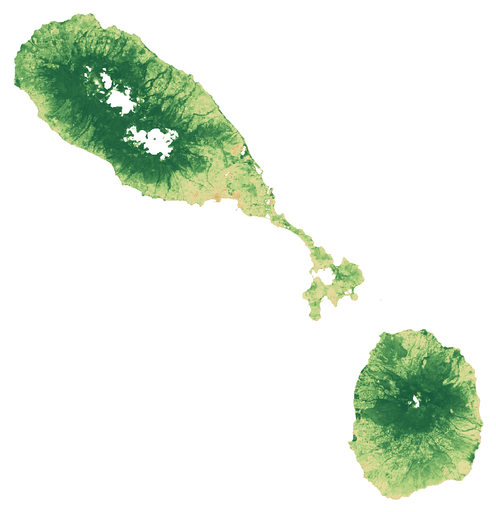
With that history in mind, explore Saint Kitts and Nevis in natural colour, through its vegetation signal and by mapped land cover. These views help frame local questions; the land records and field assessment establish what a specific site can offer.
From the satellite record
See the land.
Read the signal.
Explore the same landscape in natural colour and through its vegetation signal.
Sentinel-2 · January–September 2026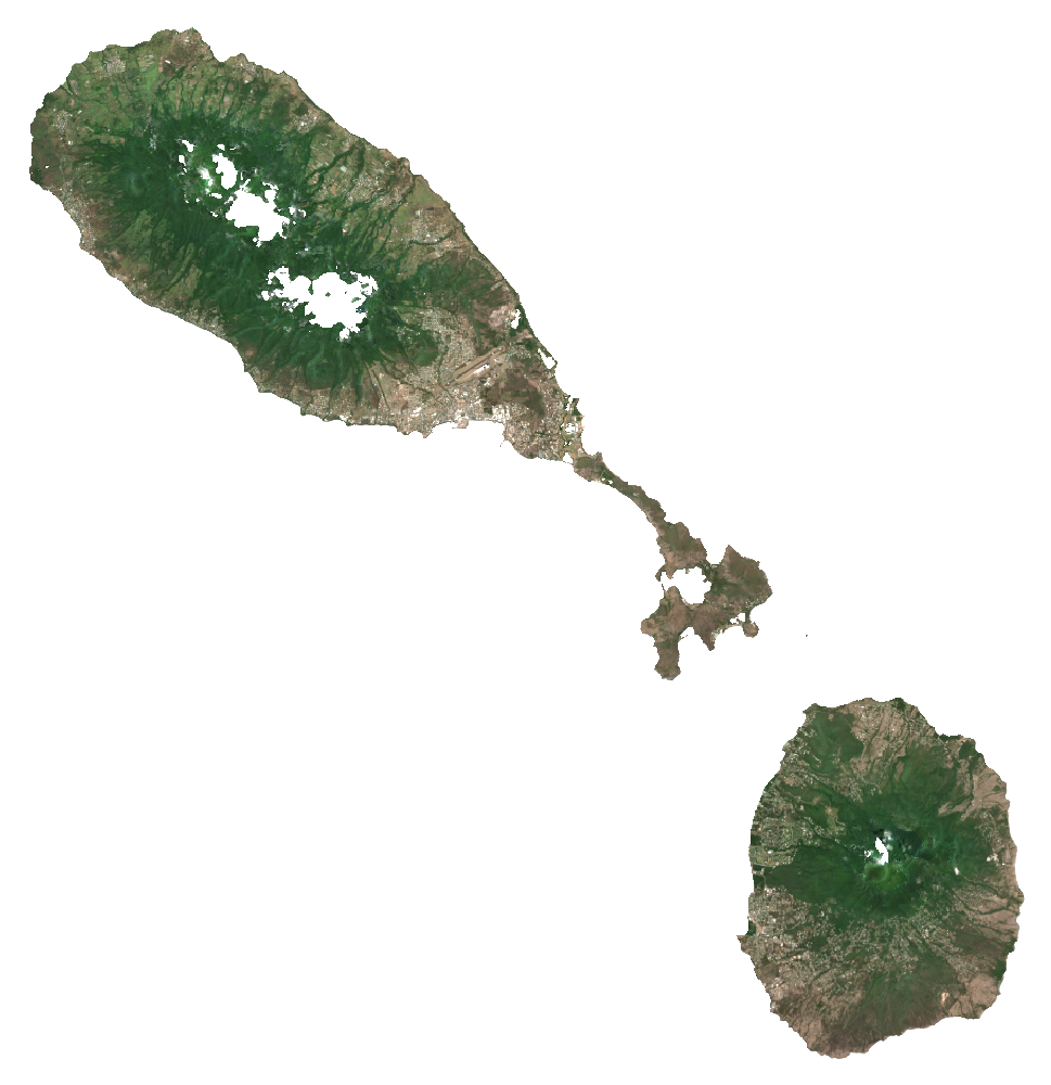
 RGB · Natural colourSaint Kitts and NevisCloud-screened median composites
Stronger vegetation signals can include forests, pasture and crops. The dark background shows masked water, areas outside the study boundary or missing data.
How to read these images and inspect the sources
Natural colour combines the red, green and blue bands (B4, B3, B2). NDVI compares near-infrared and red reflectance: (B8 − B4) / (B8 + B4). Both views use the same dated scene list and extent, with cloud and shadow screening. Each pixel summarises observations across the period; this is not a single photograph.
The colour scale is fixed across countries; values beyond its endpoints use the endpoint colours. The separate NDVI statistic is the spatial mean of the temporal-median index on the documented 1 km screening grid. Image pixels use the display grid stated above.
These views help guide a closer inspection. They do not identify available rental land, confirm ownership or measure agricultural suitability.
- A temporal median of observations in January–September 2026, not a single-date photograph.
- RGB and NDVI use identical bounds, display grid and valid-pixel masks. Higher NDVI indicates greater spectral greenness, not crop identity, yield, land vacancy or suitability.
- Transparent pixels represent the selected boundary/land mask or missing valid observations, not proof of absent vegetation.
- The overview grid is for display. The published numerical screening uses a separate 1 km grid; do not extract hectares or availability from these coloured pixels.
- Cloud and shadow masking can leave residual haze or remove valid surfaces. Native 10 m source bands do not make the overview a 10 m product.
- Component islands shown are those represented in the documented boundary; small features can be difficult to distinguish at overview scale.
Download the imagery reproduction package ↓
Contains modified Copernicus Sentinel data (2026), processed for CaribVista.
The 2021 land-cover baseline
What covers the landscape?
Saint Kitts and Nevis26,245.4 mapped hectaresAll classified pixels in the selected boundary, including water
Explore a class in the chart or legend.
Grassland
6,874.6 haThis class includes managed pasture and natural grassland. It does not identify vacant, idle, leasable or cultivable land.
View the values and boundary notes
| Land-cover class | Hectares | Share |
|---|---|---|
| Tree cover | 15,624.8 | 59.5% |
| Shrubland | 1,253.5 | 4.8% |
| Grassland | 6,874.6 | 26.2% |
| Cropland | 102.3 | 0.4% |
| Built-up | 1,880.7 | 7.2% |
| Bare / sparse vegetation | 63.3 | 0.2% |
| Snow and ice | 0 | 0.0% |
| Permanent water | 390.3 | 1.5% |
| Herbaceous wetland | 29 | 0.1% |
| Mangroves | 27 | 0.1% |
| Moss and lichen | 0 | 0.0% |
| Total mapped area | 26,245.4 | 100% |
Boundary source: FAO/GAUL/2015/level0. Calculation: 11 October 2026. Rounded values may not add exactly; downloads retain the source values.
- Selected national polygon was matched uniquely; mapped area and reference surface were compared. Coastline and all minor island membership are not certified by a national agency.
- Earth Engine geometry area and raster pixelArea use different area conventions; their ratio is a sanity check, not a valid-pixel or classification-accuracy percentage.
ESA WorldCover 2021 v200 · Historical observations · Reviewed 11 October 2026.
Shares use classified pixel area inside each selected screening boundary, including mapped water. They do not measure available farmland. Local classification accuracy and parcel availability are not established.
05Land and access
From a land lead
to a workable parcel.
A country programme or a patch of grassland helps direct the search. A pilot needs a specific place, clear rights and a current agreement.
A joint ministerial statement in November 2025 addresses harmonising residential and agricultural land use. Historical sugar ownership does not establish a present agricultural allocation.
What the satellite evidence supports
A fresh calculation using the documented country boundary is complete. Source artifacts, area checks and processing details are preserved. Local classification accuracy and legal land access have not been established.
Land cover describes vegetation; it does not establish vacant, accessible or plantable land. ESA WorldCover v200 observes 2021. Newer Sentinel screening has its own dates, quality controls and geographic scope.
Boundary scope: Selected national polygon was matched uniquely; mapped area and reference surface were compared. Coastline and all minor island membership are not certified by a national agency. Earth Engine geometry area and raster pixelArea use different area conventions; their ratio is a sanity check, not a valid-pixel or classification-accuracy percentage.
A separate Sentinel-2 screening for January–September 2026 completed on a 1 km sampling grid. It checks the monitoring workflow and records observation coverage. It is too coarse for parcel decisions and does not establish current land use or availability.
ESA dataset and methodologyHistorical programmes and listings need current written confirmation. Gross parcel area and net plantable area are separate decisions.
06Production priorities
Design around the site
and the people using it.
Government reporting highlights drought and water-security investment. Require site water allocations/storage and island-specific access, handling and market tests; treat announced new infrastructure as unavailable until completion and operating capacity are verified.
Compare proposed production with current use. Protect existing livelihoods and valuable habitats. Choose crops and farming systems after soil, water, market and farm-management checks.
- SKNIS: agriculture and drought challenges 2025-01-10; event 2025-01-09
These are proposed feasibility priorities. Sources provide country context and do not establish a CaribVista partnership.
08Check the evidence
Country sources, dates and access limits 11 records · Reviewed 11 October 2026
History and local context
- Government of Saint Kitts and Nevis: Key business sectors — historical account of the July 2005 sugar closure ↗
- Saint Kitts and Nevis Information Service: Former sugar workers benefit from additional payments ↗2018-09-03
- Government of Saint Christopher and Nevis: 2026 Budget Address, agriculture on printed pages 11–12 ↗2025-12
- Nevis Island Administration: Water tank, shade house and storage facility support food security ↗2026-03-31
Land, agriculture and programme evidence
Records distinguish primary text reviewed from excerpts and material that could not be retrieved. A source’s publication date and the review date serve different purposes.
- CARDI strategic plan 2024–2028
2024–2028 plan
Access: primary text reviewed. Regional research mandate and existing crop, livestock and resilience work; candidate institution, no CaribVista partnership. Accessed on the review date; this does not make historic data current.
- ESA WorldCover data access
2021 reference map; 2022 release
Access: primary text reviewed. WorldCover v 200 is land cover, not a cadastral, vacancy, crop-yield or legal-availability survey. Accessed on the review date; this does not make historic data current.
- St Kitts and Nevis Budget Address 2026
2025-12; budget 2026
Access: primary document retrieved relevant text reviewed. Crop and planting programmes; targets and expected harvest/job figures must not be presented as achieved. Accessed on the review date; this does not make historic data current.
- Joint ministerial statement on residential and agricultural land use
2025-11-04
Access: primary text reviewed. Competing land uses and coordination; no confirmed vacant former-sugar allocation. Accessed on the review date; this does not make historic data current.
- St Kitts and Nevis agricultural transformation strategy 2022–2031
2022–2031 strategy; hosted 2024
Access: primary text reviewed. Data, tenure, water, production and institutional gaps; historical 2000 census discussion. Accessed on the review date; this does not make historic data current.
- SKNIS: agriculture and drought challenges
2025-01-10; event 2025-01-09
Access: primary text reviewed. Water security, irrigation investment and existing agricultural support. Accessed on the review date; this does not make historic data current.
- FAO agricultural census participation by round
Publication date not established
Access: primary text reviewed. Round listing; a listed year is not proof that final results have been released. Accessed on the review date; this does not make historic data current.
The next conversation
Help shape a pilot in Saint Kitts and Nevis.
Bring a local delivery team, a candidate site or a route to customers and households. Together, the next task is to agree the preparation work, its responsibilities and its budget.
Discuss a preparation partnershipAn invitation to prepare a project. Sites, funding and operating partnerships are still to be agreed.